Our satellite tracking of the conflict with Hamas, updated regularly
Video: AP
)
What started as a horrific attack on October 7th—when Hamas militants crossed from Gaza into Israel and murdered more than 1,300 people, most of them civilians—has become a war. Israel has put Gaza under siege, and is battering the enclave with air strikes. Already the fighting has caused more bloodshed than any previous clash between the two groups. Israel is massing its troops for a ground attack.
We are tracking the conflict using satellite imagery and data on casualties and building damage. This page will be updated regularly as information becomes available. See more coverage on our hub.
Destruction
Gaza City
Rimal
Beit Hanoun
Erez crossing
Al-Shati
Jabalia
Al-Ahli Hospital
October 2023
May 2021
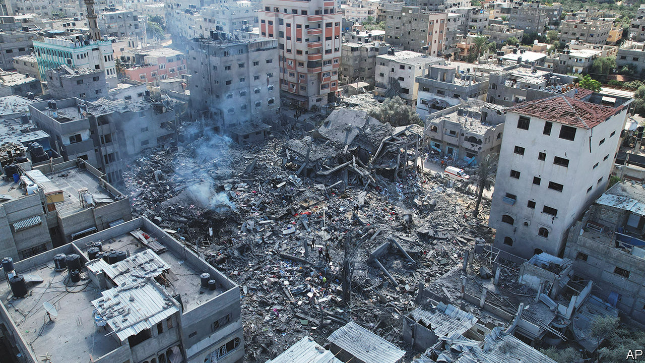
Israel reportedly dropped 6,000 bombs in the six days following Hamas’s attack. The Israeli Air Force claims to have killed hundreds of terrorists and has targeted weapons-production sites, rocket systems and Hamas command centres. Sources in Gaza report massive collateral damage.
Our analysis of open-source satellite images shows the scale of the destruction. We used data from Sentinel-1, a satellite that flies over Gaza three times every 12 days. By comparing images taken in the six months before the war began with the image from October 12th we have identified damaged areas. The slider allows you to compare the scale of the damage with that after the first week of the previous offensive in 2021.
The city of Beit Hanoun appears to be the worst hit. Sources on the ground confirm that the Al-Sousi and Ahmed Yassin mosques—which our analysis highlighted as damaged—have been levelled. Parts of the Al-Shati and Jabalia refugee camps have also been damaged. These are among the most crowded neighbourhoods in the densely populated region (see map below). Dozens of people have reportedly been killed in the strikes there.
Strikes appear to have hit major roads, making it difficult for people to move around. On Friday, October 13th (after this image was taken) Israeli forces told all 1.1m Palestinians living in the north of Gaza to flee. Later that day two explosions struck a large road leading to the south. Hamas has accused Israel of targeting civilians travelling on a route that Israel declared to be safe, but Israel has blamed Hamas, claiming they killed their own people for “political purposes”.
And on October 17th there was a large explosion at a hospital in Gaza City. Gaza’s Hamas-run health ministry claimed the blast killed hundreds of people, and blamed Israeli forces for the strike. Israel countered that the blast was caused by a failed rocket fired by Palestinian Islamic Jihad, a militant group, and that Hamas had inflated the number of casualties. President Joe Biden, on a visit to Tel Aviv, cautiously backed Israel’s version of events.
Casualties
Cumulative deaths reported by each side*
To Friday October 20th
Israeli
Reported by Israel
Palestinian
Reported by Gaza Ministry of Health†
Days since start of war
Days since start of war
*By day that deaths were confirmed, which may differ from day of death.
†Includes West Bank figures from UNOCHA. 2023
figure excludes 1,500 Hamas fighters that the IDF claim to have killed in
Israel
The conflict has already exacted a grim cost. Hamas’s attacks have killed more than 1,400 civilians and soldiers in Israel, and injured more than 4,500, according to authorities there. The Gaza Ministry of Health reports that Israel’s response has killed more than 4,000 people in Gaza and injured another 13,000. Exact figures are hard to verify, but the death toll is rising more quickly than in any previous clash between the two sides. Between 2008 and 2023 extended conflicts and other bursts of violence between Israel and Hamas killed 5,360 Palestinians in Gaza. Tragically, the war looks set to cost far more lives on both sides.
Displacement
Population density, 2020
Low
High
2 km
N
Evacuation
zone
Jabalia
Al-Shati
ISRAEL
“Safe” roads out
Wadi Gaza
riverbed
Refugee
camps
Mediterranean
Sea
Khan Younis
Gaza Strip
Gaza
Strip
Rafah
ISRAEL
EGYPT
Crossing
2 km
Evacuation
zone
Gaza
Strip
Mediterranean
Sea
Jabalia
ISRAEL
Al-Shati
“Safe” roads out
Refugee
camps
Wadi Gaza
riverbed
Khan Younis
ISRAEL
Gaza Strip
Rafah
EGYPT
Crossing
Population density, 2020
Low
High
Ahead of its planned ground invasion the Israeli army has told Palestinians living in the north of the Gaza Strip, who include residents of Gaza City, the territory’s largest (of which drone footage from October 10th can be seen above), to flee south of the Wadi Gaza riverbed. The strip is small—41km long and 10km wide—but with only two roads connecting the north and south, and air strikes happening every day, the journey is difficult and dangerous.
If the 1.1m residents of northern Gaza do reach the south, the UN warns, their arrival could cause a humanitarian disaster. Gaza is already a crowded place. If its entire population were to move to the smaller built-up areas in the south, the density in those areas would reach an estimated 19,500 people per square kilometre. That would make the urban parts of southern Gaza more densely populated than Delhi in India, Alexandria in Egypt or Karachi in Pakistan, some of the most packed places on the planet. Most of the hospitals are in the north, too. ■
Sources: European Commission; European Space Agency; Open Street Map; UNRWA; UNOCHA; The Economist